
Key Benefits
Our drone solutions deliver comprehensive diagnostics for PV installations through thermal and visual imaging with AI analytics, providing actionable insights that maximize yield and reduce costs throughout your asset's lifecycle.
-
40% Reduction in O&M Costs through targeted maintenance planning
-
100% Module Coverage, ensuring no issues go undetected
-
3X Faster Inspections than traditional methods
-
Early Detection of invisible faults before they cause major failures
-
Data-Driven Maintenance prioritized by actual impact on production
Asset Maintenance & Optimization
Our aerial intelligence transforms reactive maintenance into proactive optimization, extending asset lifespan and reducing costs while maximizing energy yield.
Comprehensive PV Inspection
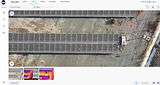
Drone-based thermal and visual mapping covers 100% of your installation in hours, detecting hotspots, module failures, and issues invisible to the human eye before they cause significant energy loss
-
Radiometric Thermal Orthomosaic
-
IEC TS 62446-3 Thermal Anomaly Report
-
Visual Defect Mapping
-
String Performance Comparison Data
Performance Analysis & Diagnostics
AI-powered analytics convert thousands of images into classified anomalies with severity ratings, providing objective data for both immediate action and warranty documentation
-
Anomaly Classification Database
-
Module Failure Analysis Report
-
Thermal Pattern Recognition Analysis
-
Performance Degradation Assessment
Targeted Maintenance Planning
GPS-tagged issue mapping enables technicians to navigate directly to problem areas, with prioritized actions based on production impact to optimize resource allocation and maximize ROI
-
GPS-Tagged Anomaly Map
-
Severity-Ranked Maintenance Database
-
Performance Impact Quantification
-
Verification Survey Comparison

Site Assessment & Development
Our aerial intelligence solutions optimize PV installation development from initial planning through construction to commissioning, maximizing site potential while reducing project risks and costs.
Pre-Construction Analysis
High-precision drone topography and site assessment providing centimeter-level accuracy for optimal array placement, comprehensive shading studies, and identification of site constraints invisible from ground level
-
Topographic Survey & Digital Terrain Model (DTM)
-
Solar Resource Assessment & Shading Analysis
-
Land Classification & Constraint Mapping
-
Preliminary Layout & Access Planning
Construction Monitoring
Regular aerial documentation capturing consistent timeline comparisons of progress, earthworks verification, and material staging - all without site disruption and at a fraction of traditional monitoring costs
-
Orthomosaic Progress Maps
-
4D Timeline Visualization
-
Cut & Fill Volumetric Analysis
-
Georeferenced Progress Documentation
As-Built Verification
Complete aerial verification of the finished installation with measurable accuracy across 100% of your site, ensuring specification compliance and creating a definitive reference point for operations and maintenance
-
Module Placement & Alignment Verification
-
String Layout & Wiring Documentation
-
IEC 62446-Compliant System Documentation
-
Baseline Thermal Imaging Assessment
PV Applications
PV Applications
Small-Medium PV Parks
1-20 MW installations with optimized aerial inspection protocols for maximum coverage and efficiency.
Commercial & Industrial Rooftops
Complete rooftop system diagnostics with specialized workflows for complex building-mounted arrays.
Specialized Configurations
Tailored inspection solutions for unique installations including tracker systems and custom deployments.
Success Stories

Ergo Home Energy LTD leverages our aerial intelligence solution across their 60+ MW PV installation portfolio in Cyprus. We provide 100% site coverage with thermal imaging and AI analytics, significantly reducing inspection time while enabling precise maintenance targeting and reducing operational costs.